


















Article Contents
Article ID: CM2610116002
Views: 12A Critical Integrative Review of Slope Stability Prediction in Open-Pit Mining: Geotechnical Indicators, Modelling Paradigms, Uncertainty-Aware Intelligence, and Emerging Monitoring Systems
 PDF
PDF
⬇ Downloads: 0
1Central South University, Hunan, China
Received: 08 April, 2026
Accepted: 17 June, 2026
Revised: 01 June, 2026
Published: 13 July, 2026
Abstract:
Slope instability in open-pit mining remains a major geotechnical, safety, and operational challenge because pit slopes are affected by excavation geometry, geological discontinuities, groundwater variation, blasting disturbance, weathering, and climate-driven degradation. This paper presents a critical integrative review of recent slope stability prediction approaches in open-pit mining, with emphasis on how geotechnical indicators, modelling paradigms, uncertainty-aware methods, remote sensing systems, and artificial intelligence are being combined to support safer slope management. Rather than treating slope stability prediction as a single deterministic calculation, the review conceptualises it as a multi-layered geotechnical intelligence problem involving mechanical behavior, deformation monitoring, probabilistic risk, environmental variability, and data-driven learning. The reviewed literature is organised into numerical and probabilistic modelling, remote sensing and monitoring, machine learning and artificial intelligence, and hybrid AI–physics systems. The synthesis shows that cohesion, friction angle, rock mass classification indices, groundwater conditions, rainfall, freeze–thaw degradation, and blasting-induced vibration remain dominant indicators, but their predictive value depends on how they interact spatially and temporally. The review highlights a clear transition from isolated deterministic factor-of-safety models toward integrated, uncertainty-aware, monitoring-informed, and operationally adaptive frameworks. Key future directions include explainable AI, physics-informed learning, digital twins, climate-resilient modelling, and multi-source real-time monitoring for risk-based open-pit slope management.
Keywords: Open-pit mining, slope stability prediction, critical integrative review, geotechnical indicators, uncertainty-aware modelling, machine learning, remote sensing, hybrid AI–physics systems.
1. INTRODUCTION
Slope stability in open-pit mines is one of the most crucial issues in the mining engineering profession, and it not only influences the safety of the people involved in the mining industry but also the output of mining in general. Open-pit mining, which implies the extraction of minerals to the surface of the earth, assumes the creation of large excavations that reveal vast fields of rocks and soil to the influence of numerous stress factors [1]. These excavated slopes are important in terms of the stability of the mine, catastrophic failures, and continuous operation. The consequences of slope failure may be disastrous, and such outcomes may include loss of life, equipment destruction, and massive losses. Slope stability is a growing factor of geotechnical engineering as mining activities prove to be more complicated and deeper [2].
In the past, prediction of slope stability of open-pit mines has been based on the following: empirical techniques, engineering judgement, and little geotechnical data. Conventional methods like Limit Equilibrium Method (LEM) and Finite Element Method (FEM) have been widely applied in the measurement of slope stability [3]. Although these techniques have offered worthwhile knowledge, they usually simplify the occurrence of slope behavior and do not consider the fact that geological conditions are not homogeneous and do not take into account the uncertainties that are inherent in the materials used [4]. In addition, these traditional approaches are computationally costly and slow, especially when working with large-scale mining activities where real-time monitoring and prediction are paramount. This has necessitated the development of new strides in slope stability prediction to meet the increasing complexity and magnitude of the mining operations today. In this review, prediction is used in a wide sense and encompasses a variety of interrelated analytical capabilities involving slope stability management. For this, there are several solutions such as predictive forecasting (e.g., machine learning failure prediction and inverse velocity forecasting), deformation monitoring (e.g., InSAR and GBSAR systems), hazard and risk assessment (e.g., probabilistic and Bayesian frameworks), and geometry characterization (e.g., LiDAR based terrain segmentation). Some of the methods reviewed indirectly predict the occurrence of slope failure by observing slope deformation, quantification of uncertainty, or characterizing the geometry of the slope.
Geotechnical indicators are important in identifying the stability of open-pit mine slopes. These indicators that involve parameters like the strength of the rock mass, the nature of joints, the content of water, and the distribution of stress offer the required information regarding the behavior of the rock mass and soil in a slope [5]. Some of the most popular indicators are the rock mass rating (RMR) and geological strength index (GSI), which provide a standard method of measuring the quality of rock masses. Moreover, the importance of hydrogeological conditions, including the groundwater flow and pore pressure, is an issue whose importance has become more and more significant in affecting slope stability. The knowledge of these geotechnical parameters is key to coming up with proper models of predicting slope failures and the safety of the mining operation [6]. But most of these pointers are site-specific and change significantly between mining operations, and this renders their incorporation into universally applicable models challenging.
Due to the growing sophistication of mining conditions, combined with the constraints of conventional models, there has been an explosion of new and more sophisticated numerical modelling techniques in use. Such methods include Finite Element Method (FEM), Discrete Element Method (DEM), and Finite Difference Method (FDM), which enable a more realistic set of simulations of slope behavior through which the interactions between geological materials, water, and other external forces like blasting and mining activities are taken into account [7]. Numerical modelling helps an engineer to construct a detailed model of the slope, which gives the engineer an idea of the possible failure mechanisms, the displacement, and deformation. These techniques are computationally intensive and need detailed input data, which are not always available in large-scale mining projects despite their benefits.
Machine learning (ML) and artificial intelligence (AI) have become highly efficient in recent years as a means of increasing slope stability prediction. These are data-driven methods that use extensive datasets acquired in different ways, such as sensor networks, geological surveys, and remote sensing technologies, to forecast slope behavior [8]. Machine learning algorithms like random forests, support vector machines (SVM), and artificial neural networks have demonstrated good results in the accuracy of slope stability prediction by detecting patterns and relationships in the data that might not be evident in other traditional algorithms. These methods can combine several sources of data in real-time, which will allow monitoring and early warning of slope failures [9]. Nevertheless, there are issues in the quality of data, interpretation of the model, and generalization between the sites of the mine.
The use of emerging trends in remote sensing and real-time monitoring has also led to innovations in slope stability prediction. LiDAR (Light Detection and Ranging), UAV (Unmanned Aerial Vehicles), and InSAR (Interferometric Synthetic Aperture Radar) are some of the technologies that have made it possible to gather high-resolution, real-time data on slope deformation, surface displacement, and other important geotechnical parameters [10, 11]. Such technologies have great benefits in terms of cost-effectiveness, speed, and safety as opposed to the traditional surveying methods. The combination of remote sensing methods with numerical models and machine learning algorithms has the potential to transform the current state of slope stability prediction and offer mining operations with the instruments to make informed and real-time decisions about slope management [12].
In spite of these developments, there are a number of issues in the sphere of slope stability prediction. Integration of different data sources, transferability of different models to different mining locations, and effects of climate change on slope behavior are among the most crucial aspects that need to be addressed. Moreover, the creation of hybrid models that will integrate classical geotechnical models with the concepts of machine learning and real-time monitoring technologies is an encouraging direction of the research in the future [13].
The proposed review is expected to synthesize current research on slope stability prediction methodologies in open-pit mines, including geotechnical indicators, modelling techniques, and emerging trends. The review of publications from 2020 to 2025 presents a broad view of progress in the area, as well as gaps in the literature and directions for further research. The conclusion of this review would help in the current undertaking that the open-pit mining practices could become safer, more efficient, and sustainable by employing more accurate and reliable slope stability prediction techniques.
Previous reviews on slope stability in mining areas primarily concentrate on numerical modelling, machine learning applications, remote sensing applications and single geotechnical analyses. There are a limited number of reviews that have critically synthesized the relationship among geotechnical indicators, uncertainty-aware modelling, hybrid AI-physics systems, and climate-resilient monitoring frameworks in the context of open-pit mining. In addition, past reviews often treat slope stability as a deterministic engineering issue rather than accounting for the propagation of uncertainty, temporal degradation processes, environmental variability and real-time decision support integration.
This review is guided by four main objectives. First, it identifies the major geotechnical, hydrogeological, environmental and mining-induced indicators used in recent open-pit slope stability prediction studies. Second, it compares how numerical modelling, probabilistic analysis, remote sensing, machine learning and hybrid approaches conceptualize prediction, uncertainty and operational usefulness. Third, it integrates evidence across these different paradigms to develop an adaptive slope stability intelligence framework for open-pit mining. Fourth, it identifies research gaps related to uncertainty treatment, cross-site model transferability, real-time monitoring, climate-sensitive degradation and decision-support implementation.
The review addresses the following questions:
RQ1: Which geotechnical, hydrogeological, environmental and mining-induced indicators are most used in open-pit slope stability prediction?
RQ2: How do numerical, probabilistic, remote sensing, machine learning and hybrid approaches differ in modelling purpose, assumptions, uncertainty treatment and decision-support value?
RQ3: What conceptual understanding emerges when these modelling paradigms are considered together rather than as isolated technical categories?
RQ4: How can current evidence be integrated into an adaptive slope stability intelligence framework for safer open-pit mine slope management?
This review contributes to the slope stability literature by repositioning slope prediction as an integrated, adaptive, and uncertainty-aware geotechnical intelligence problem rather than a static factor-of-safety calculation. Its main contribution is conceptual and analytical. First, it consolidates the major geotechnical indicators used in open-pit slope stability prediction, including rock mass classification indices, shear strength parameters, hydrogeological variables, environmental degradation factors, and mining-induced disturbances. Second, it categorizes recent modelling approaches into numerical and probabilistic models, remote sensing and monitoring systems, machine learning and artificial intelligence models, and hybrid AI–physics frameworks. Third, it critically examines how uncertainty, temporal degradation, and climate-sensitive processes affect model reliability. Fourth, it identifies how emerging technologies such as InSAR, LiDAR, ground-based radar, IoT sensors, explainable machine learning, and digital twins can support operational decision-making. In this way, the review advances a critical integrative framework for understanding the transition from deterministic slope assessment toward adaptive, risk-informed, and monitoring-driven slope management.
2. REVIEW DESIGN, SCOPE AND INTEGRATIVE SYNTHESIS LOGIC
2.1. Review Orientation
This paper uses a critical integrative review approach with structured evidence mapping. This is an appropriate approach as there is no single modelling tradition that determines slope stability prediction for open pits. Instead, it is based on geotechnical engineering, mining engineering, engineering geology, numerical modelling, probabilistic risk analysis, remote sensing, monitoring systems, machine learning and artificial intelligence. The aim of the review is not, therefore, to describe a rigid protocol for systematic reviews, but rather, to create a conceptually structured overview of some key recent research demonstrating the development of slope stability prediction in these interrelated fields.
In this review, the term slope stability prediction is used in a wide sense. It involves traditional factor of safety estimation, deformation monitoring, failure risk analysis, inverse velocity forecasting, geotechnical parameter prediction, rainfall response analysis, groundwater response analysis, and blasting induced instability assessment, remote sensing derived displacement mapping, early warning support and decision support modelling. This broader interpretation is needed, as modern slope management is seldom solely reliant on one deterministic calculation. It is increasingly based on the joint appraisal of the rock mass properties, the geometry of the slope, groundwater pressure, the deformation behavior, the environmental degradation, the uncertainty and the operative monitoring.
The Adaptive Slope Stability Intelligence Framework proposed in this review is shown in Fig. (1). As per the framework, the prediction of slope behavior starts with geotechnical and environment parameters like rock mass properties, slope geometry, groundwater pressure, rainfall, blasting vibration, weathering, deformation history and the weather sensitive conditions. Such inputs go into a series of analytical frameworks such as numerical modelling, probabilistic analysis, remote sensing, machine learning and hybrid AI–physics systems. The framework also emphasizes uncertainty validation and ongoing monitoring and adaptation as key elements to enhance the predictiveness of the system. The products it generates are stability assessment, early warning, risk-ranking, design optimisation and operational decision making. Therefore, (Fig. 1) serves as a summary diagram and is also the conceptual model upon which the review is organized.
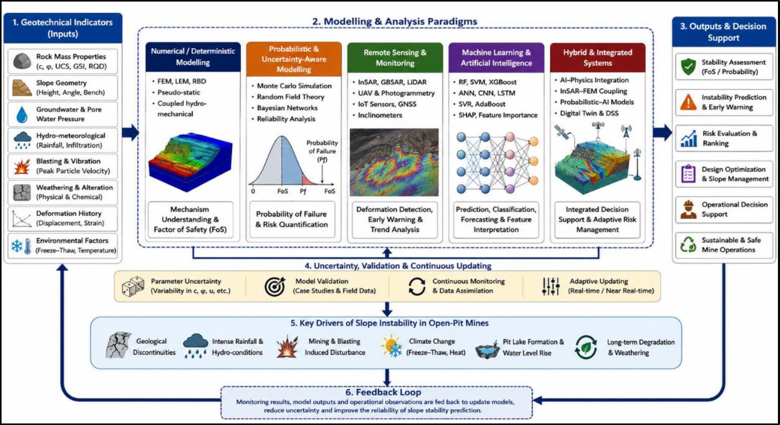
Fig. (1). Adaptive slope stability intelligence framework for open-pit mining.
2.2. Review Scope and Evidence Mapping
The reviewed studies are primarily from the last 6 years (from 2020 to 2025) due to the recent development of the artificial intelligence, remote sensing, probabilistic modelling, real-time monitoring and hybrid decision-support systems for open-pit slope stability prediction. Earlier approaches that are still relevant to recent developments, such as limit equilibrium analysis or finite element modelling or rock mass classification, are discussed.
The evidence base focuses on open pit and open cast mine slopes. Relevant studies were those that dealt with predicting the stability of slopes, assessment of slope failure, slope deformation monitoring, probabilistic risk assessment, geotechnical modelling, environmental degradation, remote sensing, machine learning and/or decision support systems in the context of mine slopes. Research on natural slopes, tunnels, embankments, dams or underground mines was not considered as core evidence unless there was a clear connection between the methods used and open-pit slope prediction.
The selected evidence found its way into five general families: numerical modelling and geomechanical modelling, probabilistic modelling and uncertainty-aware modelling, remote sensing and monitoring, machine learning and artificial intelligence, hybrid/integrated decision-support systems. This mapping was not intended to be a classification of approaches, but rather a tool for organizing the thinking that occurred during this review as this was the primary goal of this review, to get a sense of how these approaches work together in terms of slope stability intelligence.
2.3. Literature Identification and Evidence Orientation
A structured but flexible search of academic literature, which contains indexes on research related to mining, geotechnical, remote sensing, and computational intelligence, was conducted to identify relevant literature. The primary academic sources used were ScienceDirect, Springer Nature Link, IEEE Xplore and Taylor & Francis Online while Google Scholar served as a secondary source to locate interdisciplinary or recently indexed research. The search was not designed to be a complete systematic review protocol, but rather it was employed as a tool to build an even evidence base on the major stability prediction technical traditions used in open-pit slope design.
The search terms included open-pit mining, open-cast mining, slope stability, slope failure, slope monitoring, prediction, risk assessment, deformation, numerical modelling, finite element modelling, limit equilibrium analysis, probabilistic analysis, random fields, Bayesian networks, machine learning, artificial intelligence, InSAR, LiDAR, radar, UAV, IoT, rainfall, groundwater, blasting, weathering, freeze-thaw degradation, cohesion, friction angle, RMR and GSI. The following terms were employed to assure that the primary methodological families and indicator groups for slope prediction in the review were identified.
The search process was not only employed as a screening process, but also as a means to facilitate thematic evidence mapping. Studies were read in the context of their conceptual and practical contribution – either explaining the mechanisms of slope failure, quantifying uncertainty, detecting deformation, predicting patterns of non-linearity, or early warning – or contributing to integrated decision support. This enabled the review to extend beyond the story of finding a suitable model in a data base to a more holistic approach that developed into an understanding of the contribution of the various modelling traditions to the management of the stability of open-pit slopes. Database searches were re-run and checked on 14 May 2026to ensure the last evidence base was up-to-date and the chosen studies sufficiently covered the major methodological categories in slope stability prediction of 2020-25 (Table 1).
Table 1. Search transparency matrix for structured evidence identification.
Database / Source | Role in Review | Main Search Focus | Example Search Syntax | Reporting Requirement |
ScienceDirect | Main academic source | Engineering geology, numerical modelling, FEM, LEM, probabilistic slope analysis | (“open-pit mine” OR “opencast mine” OR “open cast mine”) AND (“slope stability” OR “slope failure” OR “pit slope”) AND (“prediction” OR “risk assessment” OR “numerical modelling” OR “finite element” OR “probabilistic”) | Report exact search date, filters, and date range |
Springer Nature Link | Main academic source | Geotechnical engineering, mining slope behavior, rainfall, weathering, freeze–thaw effects | (“open-pit mine” OR “opencast mine”) AND (“slope stability” OR “slope failure”) AND (“geotechnical indicators” OR “groundwater” OR “rainfall” OR “weathering” OR “freeze-thaw” OR “machine learning”) | Report exact search date, filters, and date range |
IEEE Xplore | Technical and computational source | Remote sensing, radar, IoT, monitoring systems, machine learning, sensor-based prediction | (“open-pit mine” OR “opencast mine”) AND (“slope monitoring” OR “slope stability” OR “failure prediction”) AND (“InSAR” OR “LiDAR” OR “radar” OR “IoT” OR “machine learning”) | Report exact search date and conference/journal filters |
Taylor & Francis Online | Supplementary academic source | Mining geotechnics, rock mass behavior, blasting, probabilistic risk, remote sensing | (“open-pit mine” OR “opencast mine”) AND (“slope stability” OR “pit slope”) AND (“rock mass” OR “blasting” OR “probabilistic analysis” OR “remote sensing”) | Report exact search date, filters, and date range |
Google Scholar | Supplementary discovery source only | Broad interdisciplinary discovery of recent or cross-indexed studies | “open-pit mine slope stability prediction machine learning remote sensing probabilistic modelling”; “pit slope monitoring InSAR radar failure prediction” | Report as supplementary only; do not treat as primary reproducible database |
2.4. Evidence Selection and Relevance Criteria
The studies were included only if they made a clear technical or conceptual contribution to open-pit or open-cast mine slope stability prediction, monitoring, risk assessment or decision support. Journal articles and full conference papers that were peer-reviewed and reported on geotechnical indicators, modelling techniques, monitoring technologies, empirical results or the implications for the use of open-pit slopes were given priority.
The selection process was based on the relevance and conceptual contribution of the applicants, and not on the numerical score. This is appropriate as the studies are reviewing different types of evidence and aims. In fact, there is no single quality score that can be used to provide a fair comparison of a finite element model, an InSAR monitoring study, a random forest classifier, a Bayesian risk model, and a hybrid AI–physics framework. The value is associated with their various roles in slope stability prediction. A finite element model, an InSAR monitoring study, a Random Forest classifier, a Bayesian risk model, and a hybrid AI-physics framework would be unfairly compared using a numerical score since the objectives, data configuration, validation process and use of these studies are different (Table 2).
Table 2. Study selection criteria for the critical review.
Inclusion Criteria | Exclusion Criteria |
Peer-reviewed journal articles or full conference papers | Non-peer-reviewed blogs, commercial webpages, and unsupported online content |
Published between 2020 and 2025 | Studies outside the review period unless used only for background context |
Focused on open-pit, open-cast, or mine-related slope stability | Studies focused only on natural slopes, tunnels, underground mines, embankments, or dams with no open-pit relevance |
Addressed slope stability prediction, monitoring, failure assessment, deformation forecasting, risk analysis, or decision support | Studies without a clear slope stability, monitoring, or prediction component |
Reported geotechnical indicators, numerical models, probabilistic methods, remote sensing data, ML/AI models, or hybrid systems | Studies lacking methodological clarity or technical relevance |
Included empirical, numerical, case-study, monitoring, modelling, or computational evidence | Duplicate papers or records with insufficient technical detail |
Available in English | Studies not available in English |
2.5. Methodological Interpretation of Evidence
The selected studies were discussed in terms of their methodological approach, their sources of data, their geotechnical markers, their models and their use, their methods of validation and their usefulness. The numerical modelling studies were discussed for their capability to explain the mechanical behavior, stress redistribution, deformation, hydro-mechanical coupling, response to rainfall, blasting effects, hydro–mechanical degradation and weathering. The interpretation of the probabilistic studies was based on the methodology used to represents the uncertainty of the parameters, spatial variability and reliability logic and probability of failure.
The use of remote sensing and monitoring studies in detecting deformation, capturing the spatial-temporal movement of slopes, providing early warning and monitoring inaccessible or high-risk slopes was considered. The studies of machine learning and artificial intelligence were translated based on the following input variables, predictive performance, feature importance, explainability, data quality, overfitting risk and cross-site transferability. The studies were split into hybrid and integrated studies, with the latter being evaluated based on their capability to link together physical modelling, monitoring data, probabilistic reasoning and decision-support functionality.
This interpretive approach supports the integrative purpose of the review. It does not attempt to place all the evidence on a single evaluation scale, but rather it identifies the contribution of each paradigm to a comprehensive intelligence framework of slope stability (Table 3).
Table 3. Methodological appraisal framework.
Methodological Group | Main Purpose | Typical Data Sources | Main Indicators | Appraisal Focus | Common Limitation |
Numerical modelling | Simulate mechanical behavior and estimate factor of safety | Field data, laboratory testing, slope geometry, geological models | Cohesion, friction angle, GSI, UCS, slope height, slope angle, pore pressure | Mechanical interpretation, stress redistribution, deformation and failure mechanisms | Often deterministic, site-specific, and computationally demanding |
Probabilistic modelling | Quantify uncertainty and probability of failure | Parameter distributions, Monte Carlo simulation, random fields, Bayesian networks | c, φ, groundwater uncertainty, spatial variability, probability of failure | Reliability logic, uncertainty treatment, failure probability, sensitivity to input variability | Sensitive to assumed parameter distributions |
Remote sensing and monitoring | Detect deformation and support early warning | InSAR, GBSAR, radar, UAV, LiDAR, GNSS, inclinometers, IoT sensors | LOS displacement, deformation velocity, crack growth, terrain geometry | Spatial-temporal monitoring capability, deformation detection, early-warning relevance | Limited subsurface interpretation and direct mechanical explanation |
Machine learning and AI | Predict stability, classify failure risk, forecast deformation, or estimate geotechnical parameters | Simulation datasets, monitoring data, case-study datasets, geotechnical databases | c, φ, slope geometry, rainfall, deformation, rock mass class, pore pressure | Predictive accuracy, explainability, feature importance, data quality, transferability | Overfitting, sparse failure data, weak generalisation |
Hybrid and integrated systems | Combine mechanics, monitoring, uncertainty, and AI for decision support | Multi-source geotechnical, sensing, numerical, and AI-based datasets | FoS, deformation, rainfall, thermal anomaly, blasting, freeze–thaw effects | Integration capability, operational usefulness, adaptive risk assessment | Complex implementation and high data requirements |
2.6. Cross-Paradigm Thematic Synthesis
Cross-paradigm thematic synthesis was used to integrate the evidence. This was done as the reviewed studies do not attempt to try to solve the same type of prediction problem wholly. There are no particular models for numerical explanation that are available for the main mechanical behavior and stress redistribution. Probabilistic models numerically represent uncertainty and the likelihood of failure. The remote sensing techniques were used to detect the deformation and to obtain spatial-temporal monitoring. Machine learning models are used to discover the predictive nonlinear patterns from the data. Hybrid systems try to integrate physical modelling, monitoring measurement data, uncertainty reasoning, and AI-based decision making.
The five lenses used in the review to integrate the various types of evidence were geotechnical indicators, modelling logic, uncertainty treatment, monitoring capability and decision-support functionality. For each study, the interpretation was not only based on the reported performance but also on the added value of the study to the overall body of knowledge of open pit slope stability prediction. Examples include a finite element study that provides the mechanistic explanation, an InSAR study that provides information on deformation observability, a Bayesian model that provides risk interpretation, and a machine learning model that provides nonlinear pattern recognition.
The integral contribution of the review is to gather together these contributions. Taken together, these findings indicate a transition from a single factor-of-safety analysis of open-pit slope stability to a dynamic and evolving process of geotechnical intelligence based on uncertainty and monitoring. This synthesis logic is also the foundation for the Adaptive Slope Stability Intelligence Framework presented in Fig. (1) and elaborated upon in the discussion. The synthesis hence underpins the key thesis of the paper: open-pit slope stability forecasting is evolving into a non-isolated deterministic evaluation to a system that is uncertain, monitored, climate-resilient geotechnical wisdom (Table 4).
Table 4. Evidence mapping of reviewed studies by methodological category.
Review Category | Representative References | Main Methods / Technologies | Main Contribution to Slope Stability Prediction |
Numerical and geomechanical modelling | [1, 3, 4, 7, 16, 19, 42, 43, 44] | FEM, LEM, pseudo-static LEM, modified Hoek–Brown modelling, coupled hydro-mechanical modelling | Explains mechanical behavior, stress redistribution, rainfall effects, weathering, blasting response, freeze–thaw degradation, and factor-of-safety variation |
Probabilistic and uncertainty-aware modelling | [6, 24, 38, 41, 46] | Random field theory, Monte Carlo simulation, Latin Hypercube Sampling, Bayesian networks, probabilistic LEM/FEM | Quantifies uncertainty, spatial variability, parameter sensitivity, and probability of failure beyond deterministic FoS values |
Remote sensing and monitoring-oriented approaches | [10, 11, 17, 21, 23, 25, 28, 30, 33, 45] | InSAR, GBSAR, radar monitoring, LiDAR, UAV, GNSS, inclinometric monitoring, IoT-LoRa systems, LSTM-supported monitoring | Detects deformation, displacement velocity, surface movement, crack evolution, terrain geometry, and early-warning signals |
Machine learning and artificial intelligence approaches | [2, 5, 8, 9, 14, 18, 20, 22, 26, 27, 29, 31, 32, 34, 35, 37] | RF, SVM, ANN, XGBoost, AdaBoost, LightGBM, SVR, CNN, LSTM, SHAP, fuzzy time series, RGAN, PSO-based models | Supports nonlinear prediction, stability classification, feature importance analysis, deformation forecasting, and geotechnical parameter estimation |
Hybrid and integrated decision-support systems | [12, 15, 28, 29, 33, 36, 39, 40, 45, 46] | InSAR-FEM, IRT-FEM, knowledge–data models, cloud models, AHP-cloud models, Bayesian risk systems, freeze–thaw-GNSS-FEM integration | Combines physical modelling, sensing, AI, uncertainty reasoning, and operational risk assessment for integrated slope management |
2.7. Methodological Limitations
This review does not purport to be a comprehensive review. Despite a structured search and transparent selection process, the intent was critical synthesis and evidence mapping as opposed to full bibliometric coverage. The results of Google Scholar were taken as an additional source of discovery due to the inability to reproduce all the results of this source fully. The type of data, modelling purpose, method of validation, and conditions of the site also vary greatly in the reviewed studies, which makes it impossible to directly compare the performance values. These constraints were resolved through grouping of the evidence based on methodological groups and the interpretation of each study based on its modelling purpose and practical contribution.
3. GEOTECHNICAL INDICATORS AS INPUT LAYERS IN OPEN-PIT SLOPE STABILITY PREDICTION
The evidence reviewed in this section shows that slope stability indicators should not be interpreted as isolated variables. Rock mass quality, shear strength, groundwater pressure, rainfall infiltration, blasting vibration, deformation history and environmental degradation operate together as interacting control layers. Their predictive importance depends on the modelling paradigm being used. Numerical models use these indicators to explain stress redistribution and failure mechanisms, probabilistic models use them to represent uncertainty and parameter variability, remote sensing systems detect their surface expression through deformation, and machine learning models use them as predictive features [14-17]. The integrative value of the review therefore lies in showing how the same indicator can have different analytical roles across different modelling traditions.
3.1. Rock Mass Rating (RMR) and Geological Strength Index (GSI)
The most commonly used indices in the reviewed studies are rock mass classification indices, and especially Rock Mass Rating (RMR) and Geological Strength Index (GSI). These indices are an integrated measure of the quality of rock masses, since they include intact rock strength, joint spacing and condition, effects of groundwater, and structural orientation.
In addition, Stolecki et al., [17] directly incorporated GSI into an artificial neural network model with the generalized Hoek-Brown failure criterion, which is able to prove that GSI was one of the strongest predictors of slope stability. They found that the predictions of ANN were highly similar to the output of numerical simulations, and GSI is an effective condensed set of rock mass behavior. Similarly, Mahmoodzadeh et al., [18] in their case study of Dexing Copper Mine applied GSI alongside joint roughness coefficient (JRC) and joint wall compressive strength (JCS) to assess deterministic safety factors as well as probabilistic risk of failure.
The degradation of the GSI over time in unfavorable environmental conditions is also mentioned in several studies. According to [19], freeze-thaw cycling in open-pit mines with a high altitude resulted in a gradual decrease in GSI, which directly corresponded to decreasing slope safety factors. This effect, which was further quantified by [20], indicated that repeated freeze-thaw cycles led to cohesion losses that are more than 70% thus indirectly lowering rock mass quality indices based on strength parameters.
These observations show that RMR and GSI remain central indicators in slope stability assessment, particularly when they are dynamically interpreted alongside environmental degradation, groundwater variation and time-dependent weakening processes.
3.2. Shear Strength Parameters (Cohesion and Friction Angle)
The parameters of shear strength, namely, cohesion (c), and internal friction angle (φ), are always found to be the most important geotechnical parameters that prescribe slope stability as failure forecasting in the studies reviewed. Empirical modelling and machine-learning-based studies both confirm the high sensitivity of stability results to changes in these parameters.
Gao et al., [21] compared several machine-learning models to predict rock slope failures and discovered that cohesion and friction angle have always been the most effective predictors in the three models (random forest, support vector machine, and artificial neural networks). Similarly, Sahoo et al., [8] showed that factor-of-safety prediction through variation in c and φ exhibited the largest variance in their machine-learning-based stability classification framework, with random forest models having a prediction accuracy of about 95%. Field-scale and laboratory-based studies also emphasize the process of shear strength degradation under environmental load. As demonstrated by Zhang et al., [22], freeze-thaw cycling led to a loss in cohesion exceeding 70% a loss in friction angle up to 50% and exponential losses in slope stability.
3.3. Hydrogeological Indicators
The hydrogeological indicators, such as the pore-water pressure, the groundwater level, the rainfall infiltration, and the seepage forces, are determined as the prevailing factors that initiate slope instability in the open-pit mines. Several case studies indicate that the hydro-geological conditions may change rapidly, leading to increased deformation and decreased effective stress. In a study, Lu et al., [23] observed the interactive impacts between mining blasting and rainwater infiltration and discovered that blasting damage was grossly enhanced by the accumulation of pore-pressure due to rainfall, resulting in more than 30% displacement. Slope stability has also been demonstrated to be influenced by post-mining hydrogeological evolution.
3.4. Blasting-Induced Stress and Mining Operations
Blasting and excavation activities leading to dynamic loading are another negative geotechnical indicator in active open-pit mines. Redistribution of the stress caused by blasting may reopen the discontinuities, lower the mass integrity of the rock, and cause slope deformation to increase. Li et al., [24] quantitatively measured the impact of blast on the ground vibrations and concluded that the maximum particle velocities of over 10.9 mm/s led to a 13% decrease in the safety factor. Xu et al., [25] also showed that cumulative damage caused by repeated blasting together with rainfall infiltration had a significant effect on the increment in the rate of slope deformation.
3.5. Case Studies Demonstrating Indicator Interactions
A number of studies clearly indicate that slope instability occurs as a result of interaction between various geotechnical indicators in relation to each other and not a single factor. Ismail et al., [26] demonstrated that the quality of the rock mass and the degradation of shear strength, as well as the excavation stage, collectively determined the probability of failures at the Dexing Copper Mine. Heddallikar et al., [27] pointed to the compound impact of freeze-thaw degradation on slope stability coupled with rock mass classification in cold mines.
To demonstrate that all the three features, namely, InSAR, infrared thermography, and numerical modelling, provided the same contribution to the slope failure processes, [28] combined them to demonstrate the deformation patterns, thermal anomalies, and mechanical indicators. These case studies highlight the increasing change towards multi-indicator and integrated evaluation framework of slope stability prediction.
4. MODELLING PARADIGMS AS ANALYTICAL LAYERS IN SLOPE STABILITY PREDICTION
The modelling approaches reviewed in this section should be understood as complementary rather than competing paradigms. Numerical modelling explains why slopes fail, probabilistic modelling estimates how uncertain that failure risk is, remote sensing identifies where and when deformation is occurring, machine learning detects nonlinear patterns in multi-source data, and hybrid systems attempt to connect these functions into operational decision support. When considered together, these approaches show that slope stability prediction is shifting from a single-output design calculation toward a multi-layered intelligence architecture. Although they are still common, especially in the field of engineering design, the constraints of such methods with regard to uncertainty and complex geological conditions have spurred the use of more sophisticated modelling techniques [4, 29].
However, caution should be used when comparing the different modelling paradigms since the methods reviewed are used to address different analytical objectives for slope stability management systems. Numerical methods like FEM and LEM are mainly used for modelling of mechanical behavior and stress redistribution, while machine learning models are used for classification or prediction problems with the help of historical data. The primary applications of remote sensing methods are deformation monitoring and early warning, and the uncertainty quantification and risk assessment are the main applications of Bayesian and probabilistic methods. The methodological superiority cannot therefore be generalized, as dependency of modelling suitability is significant regarding the operational objectives, data availability, geological complexity and monitoring requirements.
4.1. Numerical Modelling Approaches
In open-pit mine slope stability prediction, the numerical modelling is of paramount importance.The most frequently used methods in the reviewed studies are Finite Element Method (FEM), Finite Difference Method (FDM) and, to a minor degree, Discrete Element Method (DEM) to model stress-strain behavior, deformation development, and failure processes.
A number of case studies show that FEM-based methods can be effective in modeling complicated slope behavior. Fengyan et al., [28] combined field observations, laboratory testing and numerical modelling to examine the effect of weathering on open-pit slope stability. They reported that progressive weathering reduced slope stability through degradation of mechanical properties.
Yadav et al. [29] should be discussed under machine learning or hybrid numerical–ANN modelling rather than as a freeze–thaw FEM study. Their work used generalized Hoek–Brown-based stability information and artificial neural networks to predict the stability factor of rock slopes. It is therefore relevant to this review because it demonstrates how conventional geomechanical criteria can be translated into data-driven prediction tools, but it should not be used as evidence for freeze–thaw degradation. Fu et al., [30] also measured freeze-thaw-degradation by laboratory experiment and FEM and found that the loss in cohesion was more than 70%.
4.2. Probabilistic and Reliability-Based Modelling
In order to overcome uncertainty of geotechnical parameters, a number of studies embrace probabilistic and reliability-based modelling methodology. Ahour et al., [31] applied a hybrid deterministic-probabilistic model (Monte Carlo simulation with LEM) in order to assess slope stability in the Dexing Copper Mine. Their findings showed that the probability of failure of slopes that seemed to be stable during the deterministic analysis was up to 38%. Similarly, Mirmazloumi et al., [32] have factored in soil parameter uncertainty with Latin Hypercube Sampling, which has shown failure rates as high as 46.7%, an indication on the inevitable drawback of deterministic assessments.
Another significant direction in probabilistic modelling is based on Bayesian. Gao et al., [33] created a Bayesian Network model to evaluate the slope risk in cold areas and found freeze-thaw effects to be the key risk factor. All these studies show that probabilistic modelling presents a more realistic model of slope stability in case of uncertainty.
4.3. Remote Sensing-Based Modelling and Monitoring
The significance of remote sensing technologies in slope stability prediction has been on the rise especially in deformation monitoring and early warning. InSAR, ground-based SAR (GBSAR), LiDAR, and UAV-based photogrammetry are also extensively used in the reviewed studies to trace the trends of surface movement and deformation.
Dai et al., [34] also applied multi-temporal InSAR to slope stability evaluation of the Gevra Coal Mine and observed up to -30 mm/year of deformation of slope and mountainous open-pit mining regions deformation from −232 to +81 mm/year. These experiments show that InSAR is effective in the recording of long-term deformation patterns at large spatial scales.
On-ground monitoring techniques have better temporal resolution. Barkhordari et al., [35] implemented GBSAR in the opencast coal mine and obtained a spatial resolution of 0.6 m, which made it possible to detect the early-stage deformation. The study by Luo et al., [36] used radar to forecast slope failure days earlier along with an enhanced inverse velocity model and demonstrated the possible potential of radar-based forecasts.
4.4. Machine Learning and Artificial Intelligence Approaches
The most rapidly developing paradigm of modelling in slope stability prediction consists of machine learning (ML) and artificial intelligence (AI) solutions. The techniques exploit the huge datasets to establish complex and non-linear correlations between the geotechnical indicators and slope performance.
Zhang et al., [37] compared the use of ML algorithms in a detailed manner and discovered that the accuracy of the prediction by random forest models was approximately 94%. Likewise, Yadav et al., [38] used random forest models in an open-pit mine in Malaysia with a prediction of the stability accuracy in the order of 92%. An et al., [39] used Light Gradient Boosting Machine models in seismic situations and achieved an AUC of about 0.95.
Deformation forecasting is becoming more a time-series based approach. Li et al., [40] created an entire distribution optimization fuzzy time series model with lower prediction errors compared to the baseline models. Lyu et al., [41] used InSAR time series to predict the LSTM networks with RMSE that reached less than 5 mm. Du et al., [42] also improved the time-series prediction with the recurrent generative adversarial networks that minimized the mean absolute error by about 33%.
Although they perform highly, ML models have issues that are associated with data quality, interpretability, and generalization. It has been reported in numerous studies that, when site-specific data is used to train the models, the reliability of the results can be low when applied in other geological settings. Many machine learning studies have reported strong predictive performance, though this should be taken with a grain of salt. Many models have been trained with synthetic, simulated or very site-specific data sets, which may not be transferable to other geologic settings or mines. Moreover, machine learning models are often lacking in interpretability, have data imbalance issues, limited failure data, and potential overfitting when failure data is scarce. Therefore, there is no guarantee of operational robustness and generalisability under real mining conditions with high prediction accuracy.
4.5. Hybrid and Integrated Modelling Frameworks
The recent trend in the literature reviewed is the creation of hybrid modelling frameworks which incorporate numerical models, probabilistic techniques, remote sensing and machine learning. The strategies are supposed to capitalize on the strengths of both paradigms and reduce their unique drawbacks.
Jin et al., [43] also integrated in-situ InSAR, infrared thermography, and FEM in order to determine slope stability in an iron ore mine, and critical instability areas occur where the factor of safety decreased below unity due to seismic loading. Likewise, Wu et al., [44] incorporated deterministic, probabilistic, and geotechnical classification techniques to enhance the reliability of decision making.
There is also monitoring-integrated systems that are also an important direction. Dong et al., [45] established a Fog-IoT-based slope deformation monitoring system using LoRa communication to provide real-time results, which allows acquiring data with low latency. Although these systems do not actually compute safety factors, they provide streams of data that can be used in predictive modeling.
5. EMERGING TRENDS AND TECHNOLOGIES IN SLOPE STABILITY PREDICTION
5.1. Hybrid Physics-Data-Driven Modelling Frameworks
A key emerging trend is the creation of hybrid modelling frameworks that merge conventional geomechanical principles with machine learning or probabilistic intelligence. Such methods in contrast to purely data-driven models incorporate the physical knowledge in the predictive structures enhancing robustness and interpretability.
Li et al., [46] were the first to combine both deterministic and probabilistic models to study the probabilities of failures up to 38% in slopes that were considered stable using deterministic models only. The study took the concept a step further to combine InSAR deformation measurements, infrared thermography and finite element modeling, enabling thermal and surface deformations to directly drive the numerical stability models. Their outcomes showed that the factors of safety decreased to values below unity in areas that were determined using multi-sensor data fusion.
Similarly, Dong et al., [45] came up with an InSAR-based workflow that directly inputs the deformation-derived digital elevation models to slope risk prediction to close the remote sensing and mechanical analysis gap. These works suggest a change to physics-informed intelligence, with the meaning of geotechnical restricting data-based learning and not substituting it.
5.2. Deep Learning and Time-Series Forecasting
The second significant upcoming trend is the use of deep learning architectures, especially on deformation prediction and early warning. Deep learning models can, in contrast to traditional machine learning models, model temporal dependencies and progressive failure behavior, since they use dynamic input features.
Du et al., [42] found that long short-term memory (LSTM) networks with InSAR time-series data could be effectively used with root mean square errors <5mm in deformations forecasting. The study used the fuzzy time series models that are optimized by the optimization of the entire distribution and found that the prediction error is significantly less than that of the traditional statistical forecasting.
Recently more advanced architecture has been developed. To enhance the predictability of slope instability, [43] presented a recurrent generative adversarial network (RGAN) which improves the predictive error by about 33% when augmenting geotechnical time-series data. These methodologies deal with the key weakness in slope surveillance and the lack of asymmetry in failure information.
The growing popularity of deep learning represents the movement of binary stability classification to continuous deformation prediction, which allows the accelerating failure trends earlier.
5.3. Advanced Remote Sensing Integration
Remote sensing technologies have not only been developed but they have become part of the predictive modelling systems rather than just a tool used in isolation to monitor. It is now a trend in slope stability forecasting that data fusion is done across multi-platforms.
This evolution still revolves around Multi-temporal InSAR. To measure deformation between −232 mm/year and +81 mm/year in open-pit mines in the mountains, Wu et al., [44] assembled ascending and descending orbit InSAR data. SAR technologies on the ground supplement satellite-based systems in that they offer high temporal resolution. The LiDAR-based surface modelling is also becoming a key enabling technology. According to [45], an enhanced algorithm of segmenting open-pit terrain using LiDAR is applied to stepped terrain and gives an F1-score of about 75%. Although LiDAR does not specifically estimate stability, it drastically increases geometrical accuracy on the numerical and data-driven models.
Taken together, these works point to the shift in the mode of remote sensing monitoring to predictive, model-based sensing systems.
5.4. Uncertainty-Aware and Probabilistic Intelligence
The other trend that is emerging and is critical is the explicit description of uncertainty using probabilistic intelligence. Conventional slope stability tests typically minimize risk by basing them on individual deterministic safety factors. Recent research incorporates uncertainty more and more into predictive models.
Lyu et al., [41] combined soil parameters with uncertainty in the form of Latin Hypercube Sampling and probabilistic limit equilibrium analysis, and found the failure probability to reach 46.7%. Bayesian intelligence has likewise become popular. Li et al., [46] came up with a Bayesian Network model to determine slope risk in cold regions, where the freeze thaw processes are the most common instability driver. These methods are a step in the direction of risk-based slope management, in which probability of failure and confidence intervals are decision-making scales, as opposed to determinism thresholds.
5.5. Digital Monitoring Systems and IoT-Based Technologies
One of the most revolutionary emerging trends is the integration of the real-time sensing, communication, and computation. Instead of using periodical surveys, a number of studies recommend ongoing digital surveillance ecosystems.
Xu et al., [25] proposed a Fog-IoT-based slope surveillance system on the basis of LoRa communication and allowed the transmission of deformation data in open-cast mines in real time at low latency. Though their system was not the one that specifically calculated safety factors, it nonetheless created a structure of real-time data pipelines that could supply predictive models. By conducting continuous inclinometric monitoring in the Polish copper mines, the study proved the effectiveness of such monitoring in predicting millimeter-scale trends in deformation related to underground excavation. These systems allow real-time-close response and are the basis of the development of digital twins of mine slopes, a new idea that is implicitly mentioned in various studies.
5.6. Climate-Resilient and Environment-Aware Modelling
The slope instability related to climate change has become one of the most important areas of research, especially in cold and high-precipitation areas. The degradation by freezes, thaws and rain infiltration is also becoming a part of predictive frameworks. [42] and [44] measured extreme changes in rock strength that occurred because of freeze-thaw cycling, while [9] used machine learning to forecast geotechnical parameters with high precipitation conditions, with R2 over 0.90. [43] also showed that the formation of pit lakes following the closure of the mines has a major impact on pore-water pressure regime, which impacts long-term slope stability. According to these studies, there is an increased focus on predicting climate-resilient slope stability, especially under changing environmental conditions.
6. DISCUSSION
The discussion interprets the reviewed evidence through the Adaptive Slope Stability Intelligence Framework introduced in Fig. (1). The key finding was that none of the modelling paradigms could be used to reliably model slopes in a complex open-pit environment. Numerical models are used to give mechanical explanation; probabilistic models allow uncertainty quantification; remote sensing systems allow deformation observability; machine learning models allow nonlinear prediction; and hybrid systems offer a means towards operational decision support. The classification of the methods is thus just a part of the contribution of the review; the other part is that the methods are integrated within a multi-layered understanding of the intelligence of slope stability. A distinct transition can be seen when the reviewed studies are looked upon together. The prediction of open pit slope stability is shifting from static design evaluation to adaptive management of slope stability risks. However, this requires more and more interaction between geotechnical indicators, uncertainty-aware modelling, real-time or periodic monitoring, climate-sensitive degradation analysis and decision-support logic in order to manage the slope. This integration of two paradigms gives the conceptual grounding for the framework proposed in this review.
6.1. Comparative Analysis of Modelling Approaches and Types of Prediction
Fig. (2) demonstrates that machine learning and numerical modelling are the most prevalent methods of recent research, and most of the reviewed studies belong to them. Random forest, support vector machines, and gradient boosting models are machine learning models that show high predictive accuracy, which is usually more than 90% [8, 18, 22]. These methods are particularly successful in the establishment of nonlinear relationships between geotechnical indicators and slope failure products.
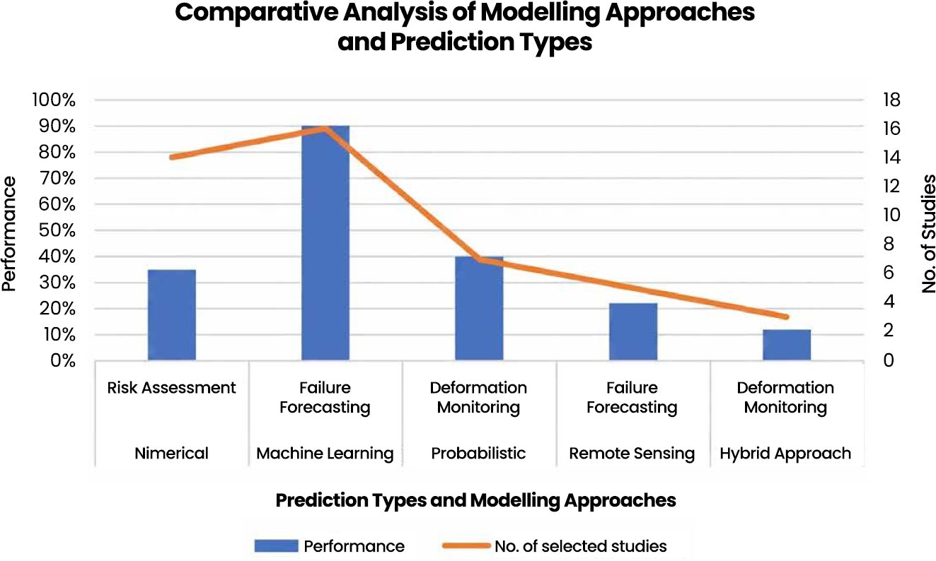
Fig. (2). Comparative analysis of modelling approaches and types of prediction.
Source: (Fig. 2) is an author-developed synthesis figure based on thematic coding of the reviewed studies; it is intended to compare the relative emphasis of modelling approaches and prediction purposes rather than to report a formal statistical meta-analysis.
Mechanistic insight and design verification are still impossible without numerical modelling, mainly FEM and LEM. Research like [1, 19] can prove that the redistribution of stress, weathering, and hydro-mechanical processes are adequately represented with the help of numerical models. Nevertheless, deterministic numerical models often are underestimating risk due to ignoring uncertainty in the parameters of the model, which is emphasized by [38, 41].
Although probabilistic models are less in number, they give an important understanding of uncertainty and the probability of failure. Bayesian networks [46] and random field techniques [6] are found to have failure probability of more than 40% in slopes that were considered to be stable by deterministic techniques. Methods of remote sensing, being less dominant, are becoming more significant in detection of deformations and early warning [11, 21]. The hybrid models are still not very strong, but this is a new frontier.
6.2. Integration of Geotechnical Indicators Across Models
Fig. (3) shows that the parameters of shear strength (cohesion, friction angle) are the most commonly assimilated when using different modelling methods, then there are rock mass quality indices (GSI, RMR). This observation aligns with the results of several researches that show that the shear strength parameters prevail in sensitivity analysis and feature importance lists [2, 18].
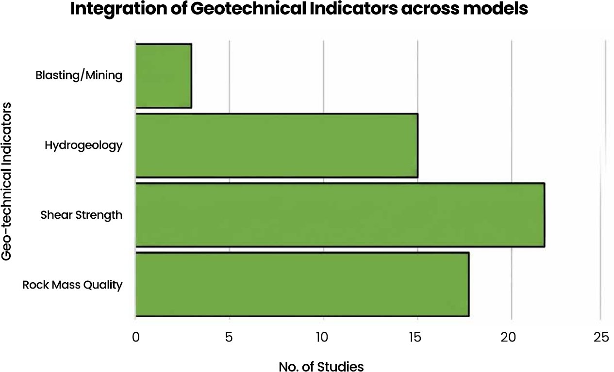
Fig. (3). Integration of geotechnical indicators in models.
Source: (Fig. 3) is an author-generated evidence-mapping figure derived from the frequency with which major geotechnical indicator groups appeared across the reviewed studies; the values represent thematic occurrence counts within the selected evidence base.
Rock mass classification indicators find extensive application in either numerical or hybrid structures. [27, 38] confirm that GSI is a useful tool to connect field observations and mechanical modelling especially together with HoekBrown based formulations. Some studies have however observed that the use of static rock mass indices can undergo temporal degradation processes unless dynamically revised [42, 44].
The destabilizing effect of hydrogeological indicators is well known but is represented in fewer studies than the shear parameters. In various case studies, it was demonstrated that rainfall infiltration and pressure of groundwater decreased safety factors more than 20% [3, 43]. This implies the lack of hydrogeological complexity in predictive models, especially machine learning models where variables of groundwater are simplified or omitted.
The indicators associated with blasting are the least common, even though quantitative data show that vibrations caused by blasts have a serious impact on slope stability making them significant. [7] showed a decrease in the safety factor by about 13% when the peak particle velocities went beyond the threshold levels suggesting that the operational factors have not been well integrated into most prediction models.
6.3. Implications of Emerging Trends
Fig. (4) shows a drastic move towards hybrid AI physics models, deep learning-based deformation predictions and combined remote sensors systems. Investigations like these by [12, 45] define how increasing the viability of establishing a connection between InSAR-derived deformation and numerical stability analysis is possible, which would allow the near-real-time assessment of risk.
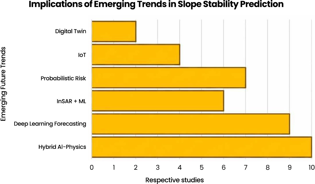
Fig. (4). Emerging future trends in slope stability prediction.
Source: (Fig. 4) is an author-developed conceptual trend map based on the reviewed literature and shows the relative prominence of emerging research directions identified during thematic synthesis.
Time-series models based on deep learning are one of the biggest innovations in the area of early warning. [28, 35] reveal that the LSTM and adversarial learning designs outclass the traditional statistical models in predicting accelerating trends of deformations. The methods are especially useful in dealing with a lack of failure data using synthetic augmentation methods.
The other trend that is prominent is the explicit in uncertainty in predictive systems. It is suggested by probabilistic intelligence systems, such as Bayesian networks and Bayesian-optimized CNNs [46]. The study by [37], whose probabilistic intelligence systems have switched the deterministic factors of safety to risk-based measures of decisions. This change is very much in line with industry demands on clear and justifiable slope management measures.
One of the most prevalent scientific gaps in the reviewed literature is the balance between comprehensiveness of physical understanding and predictive accuracy. While numerical models like FEM and LEM are mechanistic and engineering interpretable, they often lack the ability to propagate uncertainties and are not easily scalable. Unlike machine learning models, however, the models are physically explainable and can be transferred across geological environments, although the accuracy of the classification is not as high.
In the same way, remote sensing technologies offer great capabilities in deformation monitoring from a large scale, but are still constrained in subsurface characterization and in direct mechanical interpretation. The probabilistic approach offers more realistic representation of uncertainty but is impractical due to increased complexity and strong reliance on assumptions about the distributions of the parameters. The compromises highlight the fact that none of the current modelling approaches can reliably predict slope stability in highly complex mining applications.
Another limitation is operational scalability. Studies of many reviewed systems were limited to specific conditions and specific data sets, and thus, difficult to implement in industry on a larger scale. Future studies should focus on the integrated approaches that can combine monitoring, mechanics, uncertainty quantification and adaptive learning in operationally scalable systems.
7. RESEARCH GAPS AND FUTURE DIRECTIONS
Although substantial progress has been made in prediction of slope stability in open-pit mines, this review reveals some research gaps that are considered critical, thereby limiting reliability, transferability as well as the operational applicability of the current methods. The need to fill in these gaps is conducive to the development of slope stability analysis beyond site-specific studies to more powerful, adaptive, and industry-scale forecasting.
7.1. Limited Integration of Multi-Source Geotechnical Indicators
One of the biggest gaps that have been realized during the reviewed studies is the disjointed combination of geotechnical indicators. Although the shear strength parameters and indices of rock mass classification are commonly used [18, 38], hydrogeological and stresses caused by blasting are frequently either independent or not considered at all. The research by [3] and [7] illustrate the high destabilizing effect of rainfall infiltration and blasting vibrations, but these two aspects are not properly represented in machine learning and probabilistic models.
Multi-indicator fusion frameworks (which therefore include mechanical, hydrological, environmental, and operational indicators) should be the subject of future studies. This integration is of special significance to complex open-pits where mechanisms of failure are not determined by some dominant factor but rather by interacting processes. From an industry feasibility standpoint, the integration of multiple indicators is feasible but could require more robust data collection techniques, including the use of IoT sensors, and continuous real-time data logging. This would increase the accuracy of models but may also raise operational costs.
7.2. Site-Specificity and Lack of Model Transferability
The second gap is the lack of generalizability of predictive models. The success of many the machine learning models e.g., random forest and SVM, is found in specific case studies but is differed in non-compatible geological and climatic settings [22, 29]. This drawback makes the data-driven models (Like ML and Hybrid models) less practical in large mining projects that have varying pit geometries and lithologies.
The cross-site validation and the formulation of regional or global datasets along with the investigation of physics-informed machine learning models that integrate geotechnical constraints into learning structures should become the priority of future research. This might be strengthened by such methods and less reliance on big, location-specific datasets. The industrial feasibility of improving model transferability also depends on access to large-scale geotechnical databases and the adoption of cloud computing platforms. It requires significant investment in data collection and integration, especially in underexplored mining regions.
7.3. Insufficient Treatment of Uncertainty and Temporal Variability
In spite of the growing popularity of probabilistic methods, uncertainty remains poorly dealt with in most research. Deterministic models frequently include unique values of safety factors without confidence intervals, even though data show that uncertainty in model parameters can have a substantial impact on the results of stability [6, 41]. Likewise, evidently, most machine learning models utilize fixed input data that does not consider the temporal degradation through weathering, freeze-thaw cycles, or long-term groundwater processes [42, 43].
Further research in the future must focus on time-dependent and uncertainty-aware modelling that includes stochastic processes, random field theory and Bayesian updating. Incorporation of time series monitoring systems into predictive controls would be a key in the enhancement of early warning and long-term slope management.
7.4. Limited Operationalization of Real-Time Monitoring Systems
The analyzed literature demonstrates the increased attention paid to the application of real-time monitoring technologies that comprise InSAR, ground-based radar, and IoT-based sensor networks [21, 25]. Nevertheless, a majority of monitoring systems do not have a connection to predictive decision-making systems. As deformation patterns are identified, they are few times translated into practical patterns of stability forecasts or risk measurements.
Future studies should take the direction of operational digital twin frameworks, in which the real-time monitoring data is constantly updated with numerical, probabilistic or machine learning data models. These systems would provide the possible possibility of dynamic risk assessment, scenario testing as well as automatic alert generation which is a major move towards the intelligent management of mine slope.
7.5. Under-Representation of Climate-Driven and Post-Closure Conditions
The impact of climate (especially freeze-thaw degradation and excessive precipitation/rainfall) is considered to be a growing factor of slope instability [42, 44]. Nevertheless, these processes are not well represented in predictive models, particularly machine learning models, which are trained on past data which might not cover future climatic situations. This gap is particularly relevant for remote sensing models (InSAR, LiDAR) combined with probabilistic approaches to simulate varying environmental conditions.
Also, little consideration is given to post-closure slope stability, although it is known that the formation of pit lakes and long-term groundwater recovery may alleviate the situation with considerable stability [43]. Future investigations should focus specifically on climate-resilient slope stability prediction and should be conducted on the active mining stage, but also at closure and rehabilitation.
7.6. Practical Implications for Mining Engineering Practice
The findings of this review have important implications for engineering practice and operational slope management in open-pit mines. In certain unstable slopes with existing large monitoring databases, machine learning methods are especially suitable to be used for rapid screening and initial identification of unstable slopes. They can handle high dimensional data and can be used to prioritize hazards in the early stages as well as ranking operational risks.
Although newer approaches have emerged but Finite Element Method (FEM) and Limit Equilibrium Method (LEM) remain indispensable for detailed geomechanical analysis and engineering design verification, as both methods allow physically interpretable representations of stress redistribution and deformation behavior and failure mechanism. These methods are especially useful in the process of optimisation of pit design, and in excavation planning.
A long-term deformation monitoring over large spatial scales and inaccessible areas can be effectively done using remote sensing technologies, particularly using InSAR and ground-based radar systems. They can be incorporated into programmes for slope monitoring, which allow progressive failure detection and ongoing monitoring of acceleration trends in deformation.
Probabilistic and Bayesian techniques have made a major contribution to uncertainty-aware risk governance, in that they help to quantify the probability of failure instead of just applying a “safe factor. These are the methods used to enhance decision making in the uncertain geological and hydrogeological environment.
Internet of Things (IoT) based monitoring system and real time sensing technologies enable real-time data collection, which helps the development of early warning mechanisms and digital mine safety platforms. Adaptive digital twin systems for intelligent slope management could be developed in the future with the help of such systems and predictive analysis.
7.7. Adaptive Slope Stability Intelligence Framework
The synthesis developed in this review leads to an Adaptive Slope Stability Intelligence Framework for open-pit mining. This structure is a multi-layered decision process instead of a modelling-only task for slope stability prediction. The first layer is geotechnical and environmental, such as quality of the rock mass, cohesion, friction angle, slope geometry, groundwater pressure, rainfall, blasting vibrations, rock deformation, weathering and degradation due to freeze-thaw action. These are the physical and operational state of the slope.
The second layer is that of modeling and analytical paradigms. The mechanical explanation is obtained from numerical models and the quantification of uncertainty is achieved from probabilistic models; evidences of deformation in space-time are derived from remote sensing systems; the identification of nonlinear predictive relationships is performed by machine learning models; finally, hybrid models integrate mechanical, monitoring and data-driven intelligence. The third layer is the uncertainty and validation layer, where outputs from the model are compared with observed deformation, variations in the parameters, site-specific behavior of the geology and operational monitoring records.
The fourth layer is adaptive monitoring and updating layer. The interpretation of the slope behavior is continually or periodically revised as a result of feedback from InSAR, ground-based radar, LiDAR, UAV surveys, GNSS, inclinometers and IoT sensors in this layer. The last one is the decision support layer to convert the results of the modelling into stability assessment, early warning, risk ranking, design optimisation, evacuation planning, slope reinforcement and long-term closure management.
This framework brings together the core findings of the review: that there is no single modelling solution to manage complex open-pit slopes. To achieve reliable prediction, mechanical understanding, probabilistic reasoning, deformation monitoring, and pattern recognition and operation decision logic with artificial intelligence should all be used together. The proposed framework thus makes the conceptual contribution of the review and serves as a foundation for more future development of digital twins, explainable AI systems and platforms for real-time slope risk management.
CONCLUSION
This critical integrative review reviewed recent advances in the prediction of open pit slope stability through a synthesis of geotechnical indicators, numerical modelling, probabilistic analysis, remote sensing, machine learning, and hybrid decision support systems. The review reveals that the prediction of slopes is no longer properly represented by just one deterministic calculation of the factor of safety. Rather, it is becoming a process of adaptive geotechnical intelligence, which involves mechanical explanation, monitoring of deformation, quantification of uncertainty, analysis of degradation, and prediction based on data.
The results validate that the factors of cohesion, friction angle, rock mass quality, groundwater condition, rainfall infiltration, blasting vibration, deformation velocity, weathering and freeze–thaw degradation still have key roles in the assessment of open-pit slopes. However, these are not necessarily independent variables as the interaction and time-responsiveness of these variables normally lead to slope instability. Although numerical models like FEM and LEM are useful tools for understanding failure mechanism and for engineering design, probabilistic models can provide better understanding of uncertainty and probability of failure, and are useful in making engineering decisions. InSAR, LiDAR, radar, and UAV monitoring and IoT-based systems enhance the ability to gain early warnings by identifying deformation trends in space and time. Although machine learning and artificial intelligence models have excellent potential for nonlinear prediction and model interpretation, data quality, model explainability and transferability to different geological settings are critical to the reliability of these models.
The main conceptual contribution of this review is the Adaptive Slope Stability Intelligence Framework. This is a multi-layer approach to slope management with geotechnical indicators, modelling paradigms, uncertainty validation, monitoring feedback and operational decision support. It clarifies the role of the various approaches in different components of the prediction problem: Numerical models explain mechanisms, Probabilistic models quantify uncertainty, Remote sensing indicates deformation, Machine learning identifies nonlinear patterns, Hybrid systems link the functions into practical decision support.
LIST OF ABBREVIATIONS
AI | = | Artificial Intelligence |
DEM | = | Discrete Element Method |
FDM | = | Finite Difference Method |
FEM | = | Finite Element Method |
GSI | = | Geological Strength Index |
IoT | = | Internet of Things |
InSAR | = | Interferometric Synthetic Aperture Radar |
JCS | = | Joint Wall Compressive Strength |
JRC | = | Joint Roughness Coefficient |
LEM | = | Limit Equilibrium Method |
LSTM | = | Long Short-Term Memory |
LiDAR | = | Light Detection and Ranging |
ML | = | Machine Learning |
RMR | = | Rock Mass Rating |
RGAN | = | Recurrent Generative Adversarial Network |
SVM | = | Support Vector Machines |
UAV | = | Unmanned Aerial Vehicles |
AUTHOR’S CONTRIBUTION
D.J has contributed to the study conceptualization, methodology, data analysis, interpretation of results, and manuscript writing.
CONSENT FOR PUBLICATION
Not applicable.
AVAILABILITY OF DATA AND MATERIALS
The data will be made available on reasonable request by contacting the corresponding author [D.J.].
FUNDING
None.
CONFLICT OF INTEREST
The author declares that there is no conflict of interest regarding the publication of this article.
ACKNOWLEDGEMENTS
Declared none.
DECLARATION OF AI
The author used ChatGPT solely to improve the language, grammar, and readability of this manuscript. The AI tool was not used to generate, interpret, or analyze research findings, nor to formulate scientific conclusions. Following its use, the author carefully reviewed, revised, and validated the manuscript and assume full responsibility for the accuracy, integrity, and originality of its content.
REFERENCES
[1] M. Rezaei and S. Z. S. Mousavi, “Slope stability analysis of an open-pit mine with considering the weathering agent: Field, laboratory and numerical studies,” Eng. Geol., vol. 333, Art. no. 107503, 2024, https://doi.org/10.1016/j.enggeo.2024.107503.
[2] S. Wu, X. Wang, L. Han, P. He, J. Cui, H. Shen, et al., “Analysis of slope instability factors: An application study of a novel interpretable ensemble model,” Earth Sci. Inform., vol. 18, no. 2, Art. no. 413, 2025,
https://doi.org/10.1007/s12145-025-01906-w.
[3] A. Thirukumaran, L. Dananjaya, T. Dilshan, A. Dassanayake, C. Jayawardena, M. Wickrama, et al., “Stability analysis of slopes in Aruwakkalu Limestone Mine during rain: A finite element approach,” in Proc. 2020 Moratuwa Eng. Res. Conf. (MERCon), 2020, https://doi.org/10.1109/MERCon50084.2020.9185268.
[4] Y. Zhang, J. Zhang, and J. Ma, “Stability analysis of a steep rock slope in a large open-pit mine in a high-intensity area: A case study of the Yejiagou Boron Iron Mine,” Geofluids, vol. 2022, no. 1, Art. no. 9113173, 2022,
https://doi.org/10.1155/2022/9113173.
[5] H. Wang, Y. Gao, Y. Xie, S. Wu, J. Sun, Y. Zhou, et al., “Hybrid prediction model of engineering classification of slope rock mass based on DCWA-EO-AdaBoost model and BQ method,” KSCE J. Civ. Eng., vol. 28, no. 9, pp. 3722–3740, 2024, https://doi.org/10.1007/s12205-024-2523-0.
[6] Q. Zhang, H. Zhang, and L. Wang, “Influence of characteristics of geotechnical parameter random field on slope stability,” Structures, Art. no. 110445, 2025,
https://doi.org/10.1016/j.istruc.2025.110445.
[7] S. Ullah, G. Ren, Y. Ge, M. B. Memon, E. M. Kinyua, and T. Ndayiragije, “Dynamic slope stability assessment under blast-induced ground vibrations in open-pit mines: A pseudo-static limit equilibrium approach,” Sustainability, vol. 17, no. 14, Art. no. 6642, 2025, https://doi.org/10.3390/su17146642.
[8] A. K. Sahoo, J. Pramanik, S. Jayanthu, and A. K. Samal, “Slope stability predictions using machine learning techniques,” in Proc. 2022 4th Int. Conf. Adv. Comput., Commun. Control Netw. (ICAC3N), 2022, https://doi.org/10.1109/ICAC3N56670.2022.10074079.
[9] J. Gladious, P. S. Paul, and M. Mukhopadhyay, “Machine learning based prediction of geotechnical parameters affecting slope stability in open-pit iron ore mines in high precipitation zone,” Sci. Rep., vol. 15, no. 1, Art. no. 21868, 2025,
https://doi.org/10.1038/s41598-025-99026-4.
[10] T. Chen, J. Tan, P. Zhou, G. Hu, R. Yang, X. Wu, and S. Li, “EL 0: Advanced surface segmentation of LiDAR point clouds in open-pit mine stepped terrain,” IEEE J. Sel. Top. Appl. Earth Observ. Remote Sens., 2025,
https://doi.org/10.1109/JSTARS.2025.3592170.
[11] S. Chate, A. Kumar, and G. Singh, “Slope stability evaluation of open-pit mines using multi-temporal InSAR: A case study of Gevra Coal Mine, Chhattisgarh, India,” in Proc. 2024 IEEE India Geosci. Remote Sens. Symp. (InGARSS), 2024, https://doi.org/10.1109/InGARSS61818.2024.10984197.
[12] A. Siddique, Z. Tan, N. Tan, H. Ahmad, J. Li, J. Liu, et al., “Remote sensing and numerical simulation for slope stability in open-pit mining: Case study of Sijiaying Iron Ore Mine, China,” Geotech. Geol. Eng., vol. 43, no. 6, Art. no. 290, 2025, https://doi.org/10.1007/s10706-025-03254-4.
[13] C. Williams, “New statistical tools for meta-analysis in ecology and evolutionary biology,” Ph.D. dissertation, UNSW Sydney, https://doi.org/10.26190/unsworks/32252.
[14] M. Millán and R. Galindo, “Stability analysis of a homogeneous rock slope under steady-state seepage using artificial neural networks,” Eng. Appl. Artif. Intell., vol. 159, Art. no. 111556, 2025, https://doi.org/10.1016/j.engappai.2025.111556.
[15] X. Qi, H. Meng, N. Xu, G. Mei, and J. Peng, “A knowledge-data dually driven paradigm for accurate identification of key blocks in complex rock slopes,” J. Rock Mech. Geotech. Eng., vol. 17, no. 6, pp. 3726–3746, 2025,
https://doi.org/10.1016/j.jrmge.2024.09.034.
[16] C. Schmüdderich, J. Machaček, L. F. Prada-Sarmiento, P. Staubach, and T. Wichtmann, “Strain-dependent slope stability for earthquake loading,” Comput. Geotech., vol. 152, Art. no. 105048, 2022, https://doi.org/10.1016/j.compgeo.2022.105048.
[17] L. Stolecki, K. Fuławka, and T. Osadczuk, “On-line monitoring of underground workings stability with use of innovative inclinometric method: Case study from Polish copper mines,” Tunn. Undergr. Space Technol., vol. 164, Art. no. 106796, 2025, https://doi.org/10.1016/j.tust.2025.106796.
[18] A. Mahmoodzadeh, A. Alanazi, A. H. Mohammed, H. H. Ibrahim, A. Alqahtani, S. Alsubai, et al., “Comprehensive analysis of multiple machine learning techniques for rock slope failure prediction,” J. Rock Mech. Geotech. Eng., vol. 16, no. 11, pp. 4386–4398, 2024, https://doi.org/10.1016/j.jrmge.2023.08.023.
[19] P. Oláh and P. Görög, “Integrating soil parameter uncertainty into slope stability analysis: A case study of an open-pit mine in Hungary,” Geosciences, vol. 15, no. 6, Art. no. 222, 2025, https://doi.org/10.3390/geosciences15060222.
[20] Y. Hong, Z. Shao, G. Shi, Y. Dou, W. Wang, and W. Zhang, “Freeze-thaw effects on stability of open-pit slope in high-altitude and cold regions,” Geofluids, vol. 2021, no. 1, Art. no. 8409621, 2021, https://doi.org/10.1155/2021/8409621.
[21] Y. Gao, J. Li, T. Yang, L. Meng, W. Deng, and P. Zhang, “Formation of pit lake and slope stability following mine closure: A case study of Fushun West Open-pit Mine,” Geomatics, Nat. Hazards Risk, vol. 15, no. 1, Art. no. 2340612, 2024, https://doi.org/10.1080/19475705.2024.2340612.
[22] P. Zhang, Y. Bai, L. Meng, W. Yan, J. Hou, and T. Yang, “The freeze-thaw weakening of rock structural planes on slope stability: Effects of cycle numbers and burial depth,” Geomatics, Nat. Hazards Risk, vol. 16, no. 1, Art. no. 2578646, 2025, https://doi.org/10.1080/19475705.2025.2578646.
[23] Y. Lu, C. Jin, Q. Wang, G. Li, and T. Han, “Deformation and failure characteristic of open-pit slope subjected to combined effects of mining blasting and rainfall infiltration,” Eng. Geol., vol. 331, Art. no. 107437, 2024,
https://doi.org/10.1016/j.enggeo.2024.107437.
[24] E. Li, Z. Zhang, J. Zhou, M. Khandelwal, Z. Yu, and M. Monjezi, “Indirect hazard evaluation by the prediction of backbreak distance in the open-pit mine using support vector regression and chicken swarm optimization,” Geohazard Mech., vol. 3, no. 1, pp. 1–14, 2025, https://doi.org/10.1016/j.ghm.2024.11.001.
[25] X. Xu, W. Zhu, H. Li, Q. Song, Y. Wang, and N. Gao, “Rock slope landslide prediction with an improved inverse velocity model using radar monitoring data,” Eng. Geol., Art. no. 108320, 2025, https://doi.org/10.1016/j.enggeo.2025.108320.
[26] A. Ismail, A. S. Rashid, A. Dehghanbanadaki, R. H. Roslan, M. F. Dan, A. W. Rasib, R. Saari, M. Mustaffar, A. Kassim, R. A. Abdullah, and K. H. Padil, “Enhancing rock slope stability prediction using random forest machine learning: A case study,” China Geol., vol. 8, no. 4, pp. 691–706, 2025,
https://doi.org/10.31035/cg2023102.
[27] A. Heddallikar, R. Pinto, H. Kothari, J. James, Y. Rao, and T. Sajjad, “Initial results of ground-based SAR experiment in an opencast coal mine for slope stability monitoring,” in Proc. 2022 IEEE Microwaves, Antennas, Propag. Conf. (MAPCON), 2022, https://doi.org/10.1109/MAPCON56011.2022.10047045.
[28] Q. Fengyan, Z. Guangsheng, and Y. Fulian, “Application of computer artificial intelligence technology in slope stability analysis and slope numerical simulation,” in Proc. 2023 2nd Int. Conf. Artif. Intell. Auton. Robot Syst. (AIARS), 2023, pp. 298–302, https://doi.org/10.1109/AIARS59518.2023.00067.
[29] D. K. Yadav, S. Chattopadhyay, D. P. Tripathy, P. Mishra, and P. Singh, “Fog-IoT-based slope monitoring (FIoTSM) system with LoRa communication in open-cast mine,” IEEE Trans. Instrum. Meas., vol. 70, pp. 1–11, 2021,
https://doi.org/10.1109/TIM.2021.3126018.
[30] Y. Fu, L. Wan, X. Fu, D. Xiao, Y. Mao, and X. Sun, “A deformation forecasting model of high and steep slope based on fuzzy time series and entire distribution optimization,” IEEE Access, vol. 8, pp. 176112–176121, 2020, https://doi.org/10.1109/ACCESS.2020.3027206.
[31] M. Ahour, N. Hataf, and E. Azar, “A mathematical model based on artificial neural networks to predict the stability of rock slopes using the generalized Hoek–Brown failure criterion,” Geotech. Geol. Eng., vol. 38, no. 1, pp. 587–604, 2020,
https://doi.org/10.1007/s10706-019-01049-y.
[32] S. M. Mirmazloumi, Y. Wassie, L. Nava, M. Cuevas-González, O. Crosetto, and O. Monserrat, “InSAR time series and LSTM model to support early warning detection tools of ground instabilities: Mining site case studies,” Bull. Eng. Geol. Environ., vol. 82, no. 10, Art. no. 374, 2023,
https://doi.org/10.1007/s10064-023-03388-w.
[33] J. Gao and Q. Gao, “Multi-source data-driven prediction of cold-region slope failure using an SSA-PNN optimized stepwise reduction approach,” Sci. Rep., vol. 15, no. 1, Art. no. 38143, 2025, https://doi.org/10.1038/s41598-025-21824-7.
[34] M. Dai, H. Li, B. Long, and X. Wang, “Quantitative identification of landslide hazard in mountainous open-pit mining areas combined with ascending and descending orbit InSAR technology,” Landslides, vol. 21, no. 12, pp. 2975–2991, 2024,
https://doi.org/10.1007/s10346-024-02325-6.
[35] M. S. Barkhordari, M. M. Barkhordari, D. J. Armaghani, E. T. Mohamad, and B. Gordan, “GUI-based platform for slope stability prediction under seismic conditions using machine learning algorithms,” Archit. Struct. Constr., vol. 4, no. 2, pp. 145–156, 2024, https://doi.org/10.1007/s44150-024-00112-4.
[36] Z. Luo, X.-N. Bui, H. Nguyen, and H. Moayedi, “A novel artificial intelligence technique for analyzing slope stability using PSO-CA model,” Eng. Comput., vol. 37, no. 1, pp. 533–544, 2021, https://doi.org/10.1007/s00366-019-00839-5.
[37] L. Zhang, Z. Chen, Z. Zhou, J. Hao, Y. Zhou, and Y. Shen, “Failure process and mechanism analysis of rock slope induced by underground mining: A case study in Yanqianshan open-pit mine, China,” Bull. Eng. Geol. Environ., vol. 82, no. 12, Art. no. 460, 2023, https://doi.org/10.1007/s10064-023-03486-9.
[38] D. K. Yadav, P. Mishra, S. Jayanthu, and S. K. Das, “Enhanced slope stability prediction using ensemble machine learning techniques,” Sci. Rep., vol. 15, no. 1, Art. no. 7302, 2025, https://doi.org/10.1038/s41598-025-90539-6.
[39] B. An, Z. Zhang, J. Ren, and W. Zhang, “Recurrent adversarial learning for geotechnical time-series augmentation: Application to slope instability forecasting in open-pit mines,” Environ. Earth Sci., vol. 84, no. 20, Art. no. 559, 2025,
https://doi.org/10.1007/s12665-025-12566-w.
[40] G. Li, Z. Hu, Y. Wang, D. Wang, L. Wang, Z. Tao, et al., “‘Excavation-freezing-thawing’ failure and crack characteristics of open-pit slope in cold regions: A case study in Baorixile Mine, Hulunbeir, China,” Bull. Eng. Geol. Environ., vol. 84, no. 9, Art. no. 428, 2025, https://doi.org/10.1007/s10064-025-04464-z.
[41] J. Lyu, T. Hu, G. Liu, B. Cao, W. Wang, and S. Li, “Stability evaluation of open-pit mine slope based on Bayesian optimization 1D-CNN,” Sci. Rep., vol. 14, no. 1, Art. no. 13995, 2024, https://doi.org/10.1038/s41598-024-64663-8.
[42] S.-G. Du, C. Saroglou, Y. Chen, H. Lin, and R. Yong, “A new approach for evaluation of slope stability in large open-pit mines: A case study at the Dexing Copper Mine, China,” Environ. Earth Sci., vol. 81, no. 3, Art. no. 102, 2022,
https://doi.org/10.1007/s12665-022-10223-0.
[43] L. Jin, P. Liu, W. Yao, and J. Wei, “A comprehensive evaluation of resilience in abandoned open-pit mine slopes based on a two-dimensional cloud model with combination weighting,” Mathematics, vol. 12, no. 8, Art. no. 1213, 2024, https://doi.org/10.3390/math12081213.
[44] G. Wu, X. Nie, X. Zhang, M. Yang, and G. Shi, “Stability grade evaluation of slope with soft rock formation in open-pit mine based on modified cloud model,” Sustainability, vol. 16, no. 11, Art. no. 4706, 2024,
https://doi.org/10.3390/su16114706.
[45] J. Dong, H. Jiang, M. Xu, and K. Gao, “A novel InSAR-based workflow for DEM-driven slope modeling and risk prediction,” Geomatics, Nat. Hazards Risk, vol. 16, no. 1, Art. no. 2598439, 2025, https://doi.org/10.1080/19475705.2025.2598439.
[46] H. Li, X. Han, W. Zhu, X. Liu, and L. Niu, “Risk assessment of open-pit slope in cold regions based on Bayesian network,” Geomatics, Nat. Hazards Risk, vol. 16, no. 1, Art. no. 2529949, 2025, https://doi.org/10.1080/19475705.2025.2529949
Licensed
© 2026 Copyright by the Authors.
Licensed as an open access article using a CC BY 4.0 license.
Article Contents Author Danish Jameel1, * 1Central South University, Hunan, China Article History: Received: 08 April, 2026 Accepted: 17 June,
Article Contents Author Mirza Amin ul Haq1 , Shahzad Khalil2, * 1Department of Marketing, Ziauddin University, Karachi, Pakistan 2Department of
Article Contents Author Gilbert M. Talaue1, * Ishaq Kalanther1, Tomasa Gilberta D. Bitanga2 1Department of Business Administration, Jubail Industrial College,
Article Contents Author Asif Baig1, * 1Department of Business Administration, Jubail Industrial College, Jubail, Kingdom of Saudi Arabia Article History: Received:
Article Contents Author Huma Rasheed1, * , Iffat Saeed Channa2 , Samiya Kainat2 , Mohammad Affan Tahir2 1Herbal Biomedicine Inc,
Article Contents Author Murtuza Bhatti 1,2,* Imran Iqbal3 1Bath Spa University, London, United Kingdom; 2BPP University, London, United Kingdom; 3Commecs